
B.1 PUNTA BEGOÑA 100 YEARS AGO
Looking out onto the huge port facilities that dominate the mouth of the Bilbao river estuary, it is hard to imagine what the bay looked like before it was developed. The man-made changes in the recent history of the area are mainly due to developments originating from the mining of the major iron ore deposits in the hills of Triano on the left bank of the estuary.
It became necessary to make the estuary more easily navigable. This led to the setting up in 1877 of the Board of Works of the Port of Bilbao, to take charge of the work required to transform the area. The jetties, wharves, breakwaters and other port structures that can still be seen today were gradually constructed, and the two banks of the river came to have very different uses. Industrial facilities were concentrated on the left bank, while the right bank became the preferred location for the increasingly affluent middle class to build their homes: the area was conveniently close to their businesses but unaffected by the drawbacks of living next to an industrial site.
Getxo became a byword for seaside leisure pursuits, after the fashion of British coastal resorts.
It was against this background that a member of one of those affluent families acquired an exceptional piece of land. Rather than opting for the lower-lying areas of Neguri, which were more sheltered from northerly winds, or the newly flourishing district of Las Arenas with its convenient rail link with Bilbao, he chose to build on an exposed headland that had once been the site of one of the forts that guarded the approaches to Bilbao from the sea. This strategic site is an excellent spot for learning about not just the most recent developments in the area but also the changes in its landscape since time immemorial.
Why not take a stroll and learn a little about our history?
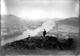
The Nervión river estuary seen from the hilltop at Enekuri (undated). Source: Archives of the Bilbao Port Authority
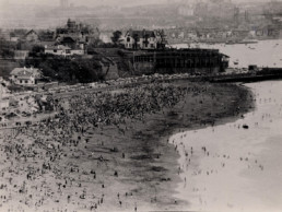
View of the residential property at Punta Begoña owned by Horacio Echevarrieta (undated). Source: San Nicolás Library
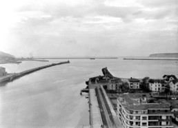
The mouth of the El Abra bay overlooking the Muelle de Evaristo Churruca pier (undated). Source: Archives of the Bilbao Port Authority