
B.4 THE RURAL GETXO OF THE PAST
Take a good look around. The landscape that you see is the result of two centuries of industrial development and urban growth of a type found throughout Europe. It is hard to imagine what the shoreline in Getxo and the El Abra Bay must have looked like over 200 years ago, when they were still unspoiled. Try to picture it.
Historical records such as 18th-century nautical charts indicate that Getxo was made up essentially of rural land, with two main populated areas. The higher ground inland was scattered with arable and livestock farmsteads, and its administrative and religious focal point was the church of Andra Mari. The second centre of population was Algorta, on the coast, a fishing port with a compact network of houses around the square and the chapel of San Nicolás, which is no longer standing.
On the right bank of the estuary beyond the Marqués de Arriluze e Ibarra promenade, where you now stand, there was nothing but sand and water. The mouth of the estuary did not follow the clear lines that can be seen today but comprised a broad stretch of marshland that changed depending on the course of the tides and the flow of the Nervión-Ibaizabal and Gobela rivers. The whole area between the cliff here at Punta Begoña and the Gasteluz Hills, where the districts of Las Arenas and Lamiako now stand, was made up of flood marshes.
The main towns on the bay were first and foremost Portugalete and to a lesser extent Santurtzi, both of which were on the far bank.
The landscape was determined by the physical environment, and was largely the same throughout the Nervión-Ibaizabal estuary where it flowed into the El Abra Bay.
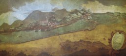
Engraving of the mouth of the estuary and the El Abra Bat, showing the sand bar at Portugalete (undated). Source: Archives of the Bilbao Port Authority
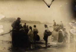
Fishermen at the Old Port in Algorta, with the great crane Titan in the background, before the Echevarrieta family home was built (1900-1910). Source: San Nicolás Library
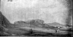
The Punta Begoña headland and Ereaga beach (undated). Source: Archives of the Bilbao Port Authority
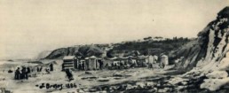
Ereaga beach with the Old Port of Algorta in the background, 1886. Source: San Nicolás Library