
D.10 VERTICAL LIMIT
One of the aspects that strikes as being most unique about the Punta Begoña Galleries is that they were built directly onto a steeply sloping cliffside. Although coastal cliffs are normally composed of strong rocky materials, their possible erosion over time needs to be monitored. A notable example of the effects this erosion may have is the recent collapse of Malta’s Azure Window formation.
Precisely in order to monitor the cliff’s stability, we have conducted an inclinometer survey that allows us to measure any horizontal movement on slopes and unstable ground.
At Punta Begoña, when we saw how distorted the walls were in the north-west gallery we decided to implement a control programme. To do so, we sank a vertical borehole (a drilling) in the garden. It is important to choose the right place for the borehole, and its depth should be more than sufficient to reach down to the layer where the ground is most definitely stable.
We inserted an inclinometer tube into the borehole, making sure the lower end was fully waterproofed. This tube has four lengthwise grooves that are set at 90o from each other. They are the guides that the measuring device will use to move up and down, and we call it a probe or torpedo: the device can measure movements to an accuracy of a hundredth of a millimetre. The torpedo is connected to a terminal that gathers the data obtained from the regular readings we take throughout the year. This enables us to measure any possible change in the slope.
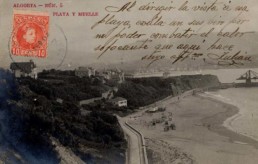
Postcard of Ereaga Beach with the barren cliff at Punta Begoña in the background, 1904. Source: San Nicolás Library
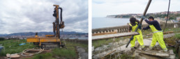
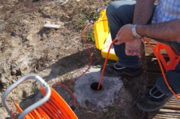
Stages in the deployment of the inclinometer probe: drilling (top left), extracting a rock core sample (top right) and taking an inclinometer reading (bottom), 2016. Source: Project for showcasing the Punta Begoña Galleries
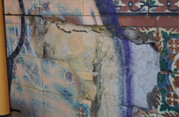
Damaged wall in the south-west gallery, 2016. Source: Project for showcasing the Punta Begoña Galleries